gipuzkoakultura.net


gipuzkoakultura.net
2026ko abuztuak 3, astelehena
During the first half of the sixteenth century a new wall was built close to San Sebastian's old mediaeval wall. The space between the two was big enough to allow the urban nucleus to be extended somewhat and in the following years the "Old Square" (Plaza Vieja) was created in the area beside the main gate leading into the town: the Land Gate [Puerta de Tierra].
There is no clear indication of who initially designed the wall. Presuming that Pedro Navarro was not involved, it seems most likely that it was built by the governor of Hondarribia, Diego de Vera. Gabriel Tadino de Martinengo worked on it around 1528, while Benedicto de Rávena also drafted a proposal in 1534.
The wall was 280 metres long, 15 metres thick and the average height above the level of the fosse was 13 metres. It consisted of an earthen rampart, nine metres thick, bordered on the outside by a main wall of ordinary masonry, six metres thick, covered on the outside in ashlar stonework. In areas next to the sea, the foundations were supported on wooden piles.
On the city-side, the rampart was bordered by a containing wall, fitted with buttresses to aid stability and stairs leading up to the adarve. Inside the wall there were seven casemates where small guns could be installed to sweep the sands below.
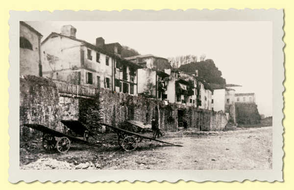
![69. Tierra [Land] Gate of San Sebastian around 1863. The Imperial Turret can be seen at the left of the photograph.](../../../img/18/grandes/69.jpg)
There were fourteen gun emplacements in the parapet (5.5 metres thick) on the top of the wall. During the nineteenth century the number was reduced to eleven. Between one emplacement and the next there was a banquette with various stairways for access.
In 1530, a bastion was built approximately half-way along the wall, known as the Imperial Turret. At the western end there was a round turret (or cubo) known as El Ingente (The Enormous One) (1542). This was replaced by the demi-bastion of St. Philip (1637-82). The corresponding counterguard had been poorly designed and was completely rebuilt between 1754 and 1755, when it was extended southwards by means of a lower sea wall ending in a ramp. The Torrano Turret was erected in the eastern section of the main wall. This was replaced by the demi-bastion of St. James (1637-82), which was slightly smaller than St. Philip's.
The inland side was completed with the external fortifications that occupied the space between the present Boulevard and the Calle de Andía. These consisted of a main fosse standing before the wall, a hornwork (1637-39) and a ravelin which protected the curtain of the hornwork. The ravelin and curatin were linked by a double caponier or covered passageway.
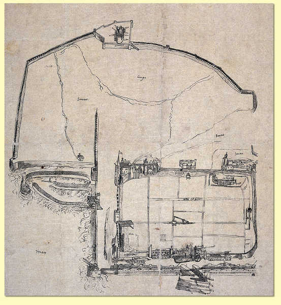
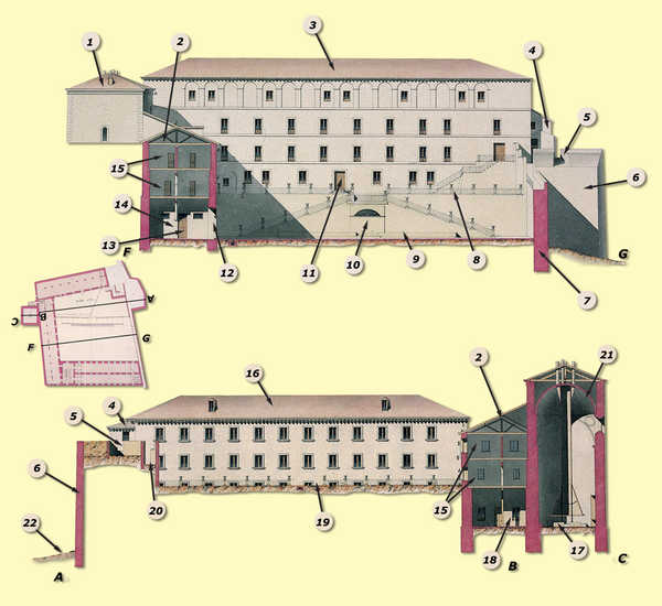
![72. The fortifications of San Sebastian in 1850:1-Imperial Turret; 2-Hornwork; 3-Ball court; 4-Southern wall; 5-St. James' Bastion; 6-Covered way; 7-Parade square in the covered way; 8-Glacis; 9-Fosse; 10-Double caponier; 11-Ravelin; 12-Counterguard; 13-St. Philip's Bastion; 14-Bridge from the Hornwork to the Tierra [Land] Gate; 15-Tierra [Land] Gate; 16-Traverse of the covered way.© Juan Antonio Sáez](../../../img/18/grandes/72.jpg)
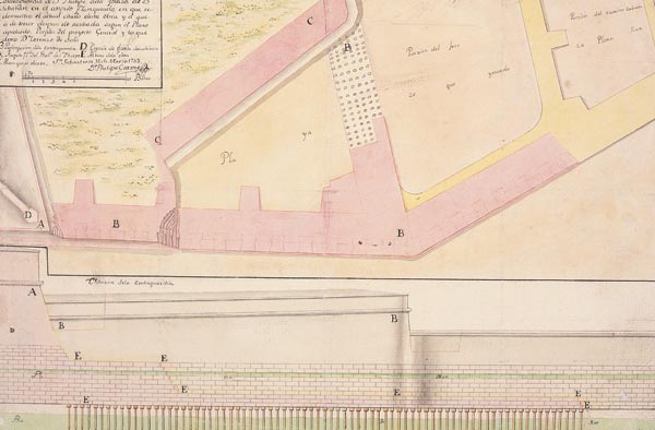
![71. 'Plano y perfiles del Frente de Tie[rra de San Sebastián en que] se demuestra las obras del Proyecto General segun las noticias y... las existentes en este presente...' by Engineer Felipe Cramer, 1754.© Carlos Mengs](../../../img/18/grandes/71.jpg)
The counterguard, hornwork and ravelin were surrounded by a secondary fosse leading into the main fosse and a covered way fitted with a parapet, parade squares and traverses. From the parapet of the covered way the ground sloped gently down the glacis. All of these elements were built after the main wall and made the casemates inoperative.
The western front was defended by a masonry wall a few dozen metres further out from the mediaeval defences. It was two metres thick and its southern section faced directly onto the sea until the new dock was built in 1851.

There was a chemin des rondes running along the top of the wall, protected by a parapet on either side. There were two gates: the "Old Quay Gate" -soon blocked off- and the "Sea Gate". In the eighteenth century, the western front was defended by two artillery pieces above the Sea Gate, with the possibility of supporting fire from St. Teresa's battery.
Following enlargement of the port (1851), the New Quay Gate was added in the area close to the present site of the Goikoa Palace. The southern front was knocked down in 1864. The western wall, however, remained relatively intact until 1880, when it was partially demolished and a promenade built on it. As well as the gates, some of the most characteristic features were various gun emplacements and embrasures -now walled over- overlooking the harbour.
The eastern front consisted of a masonry wall (known as the Zurriola Wall) in whose construction (1544) Luis Pizaño was involved. It was 264 metres long, about 3 metres thick and 10 metres high. In general, it followed the line of the mediaeval wall, since the proximity of the sea prevented any extension of the urban nucleus in this area. There was a chemin des rondes running along the top, with a parapet on either side.
To the north it was flanked by St. Elmo's Bastion and to the south by a semicircular tower known as the Amezketa Tower. Thirty metres from the Amezketa Tower stood the Los Hornos tower (both towers date from around 1542). The wall ended in an eighteen-metre stretch linking the Los Hornos tower to St. James' Bastion.
This front proved to be the weakest and was badly damaged by enemy artillery in the sieges of 1719 and 1813. After the latter, English troops built a gap in the area of the breach in the walled precinct to defend the city.
Many of the fortifications were demolished in 1864, but a considerable section of the eastern wall remained standing for several years, until the building of a new coast wall allowed the city to be extended out in this direction (the Eastward "Ensanche" or Enlargement).


